The trip north is not our favorite part. We are just going for mileage at this point. Not because we want to end the trip, but because once we have been in the Bahamas, we like the “in-between places” less.
We are not necessarily typical. Many take advantage of all the beautiful, interesting places along the Waterway: Cocoa Beach, St. Augustine, Fernandina Beach, Cumberland Island, Savannah, Beaufort, SC, Charleston, Beaufort, NC, Oriental, Elizabeth City, Great Bridge, and others. Us? Not so much. Although we enjoy the Waccamaw Swamp and visiting our friends in Beaufort, SC.
There are certain logistics to making the trip on the Waterway safer, more comfortable, and faster (our goal). We make long-term, (a general grand plan for the trip), and short-term travel plans. Our short-term planning starts the night before, when we listen to NOAA (and other) weather. Then we review the route for the next day to see how far we can go, which really means determining whether there are any anchorages at the end of 45-55 miles. If not, we plan a longer or shorter day. Plus, we factor in the weather and anything else that will affect our progress: the number of bridges we’ll have to wait for and whether there are thin water issues, open bodies of water, strong currents, etc. We usually select a target anchorage plus one or two “bail-outs” in case we opt for a shorter day, as well as one or two more distant ones so we have the option of continuing. Most days, there are no such options available.
Here is an example of how it works for us. We’d spent a day in Oriental, NC, due to 20+k winds. The next morning we left early for a long day motorsailing down the Neuse River and through the Hoboken Cut Canal, across Pamlico Sound, and up the Pungo River to an anchorage just west of the Alligator River Canal. It was a long day and windy so we were happy to reach the anchorage and relax. Plus it was my birthday. We danced to Motown, had Mexican (one of our favorite meals) and some wine, and ate chocolate. Really whooped it up. It was a pretty anchorage.

We planned to enter the 25 mile long Alligator River Canal the next day . It’s a tree-stump lined ditch that can be transited in almost any weather – the only danger is that its bottom is also lined with trees and stumps. Lots of them and often boats hit them, requiring expensive prop repairs. Here are trees that were pulled out of the Canal bottom and piled up at the edge to scare us boaters.

The Alligator Canal dumps you out at the bottom of the funnel shaped Alligator River – it’s about 20 miles to the top with a bridge in the middle. Then you are crossing 20 miles of Albemarle Sound, which has a reputation for being nasty. Wind was predicted from the NE at 10-15. Up the River and across the Sound is north and then directly NE. The wind would be on the nose – not good. And it would slow us down, making it harder to travel that far.
We selected an anchorage right at the other end of the Alligator River Canal, (off Bear Point), just before it becomes the Alligator River. And a second anchorage at the top of the Alligator River, (East and South Lakes), just before Albemarle Sound. In other words, a stopping place for each 20 mile segment, depending on the wind and wave conditions. Our goal was Buck Island in the North River, on the other side of Albemarle Sound.
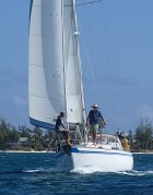
We left at 6:30 a.m. The Canal was easy; we didn’t hit any submerged trees. The Alligator River was a little rough, with white caps, but we decided it was doable and continued. The wind never built and we were able to keep a headsail up most of the time to compensate for the rolling and keep up our speed. Then, miracle of miracles, the bridge tender HELD THE BRIDGE for us. At least 5 minutes.

He was opening for boats ahead of us and we weren’t quite to the bridge yet. He said he’d have to close and open again for us when traffic cleared, but then called back to let us know he’d hold it. We counted 63 cars on the bridge, waiting for us. Some of them waved – or maybe they were giving us the finger.
We really considered the anchorage at the top of the Alligator River since wind from a better direction, i.e., not on the nose, was predicted for the next day. But the NE wind was moderating – maybe 7-10k and our route would mean a decreasing fetch as we neared the North River, so not as much wave action. So we went for it. It turned out to be a great decision as the Sound started to settle and we had a fairly comfortable crossing.
We anchored out of the channel south of Buck Island – totally open to the south, but we’d checked the weather and an east wind was predicted. We’d covered 70 miles – a personal record.
Of course, the wind went south just after dark and strengthened. We barely slept – rocking and rolling all night. And a little crab pot buoy banged against the hull right to next Goldwin’s head for half of the night and then on the other side of the boat – at my head, for the other half. We left the anchorage at 6:00 a.m., as soon as we had enough light. But the sky to our west was getting darker and darker and radar showed a storm approaching. We had to get out of where we were, with its southern exposure, and into someplace more protected. But where? We motored on the Waterway for an hour, around to the north side of Buck Island and out of the waves, and then it started to rain. We re-anchored just outside the channel in 6.5’ of water, went down below and had our breakfast. It rained hard, but not for long. So we continued, through a channel to Coinjock where we bought fuel, and on into Currituck Sound.
Wow, we didn’t expect the wind and waves we found there. Blowing from the SE at 15-20. [Were we glad we’d crossed Albemarle Sound the day before!!!] We love our boat, but she does not take waves on the back quarter well – careening abruptly as she rides up an oncoming wave and then veering sharply back as she surfs down the other side. Us trying to hang on. For a couple of hours. Luckily there is not much fetch in this shallow Sound, so the waves weren’t very big. And the headsail helped to steady the boat. We were making amazing speed, but what a ride.
We reached Great Bridge, tied to one of the free docks just south of the bridge/lock and walked to a grocery store and restaurant. Tomorrow we will go through the bridge and a small lock that controls the water height between Currituck Sound and the Chesapeake, get through a couple more bridges, and, hopefully reach Hampton, VA, where we will be staged to wait for weather to sail up the Chesapeake to home. Or we’ll carry on to Deltaville, our “long day” option.
The Intercoastal Waterway starts in Norfolk, VA. When we reach Hospital Point, Mile 0, we will have completed 950 Waterway miles – from Vero Beach to Norfolk – in 24 days. Not going for a record – just getting home.

We have a 30 foot boat I want to take down the ICW. I could imagine exactly what it would be like through your riviting narrative. Sorry I’m joining the crew just as the journey ends.
Wow, must be very different to sail on all that ‘brown’ colored water after the wonderful blue and green water all winter!